Managing the
marsh
A major reclamation project is planned for Robbins’ Marsh, with an aim of improving water quality and enhancing wildlife habitat
The public comment period concerning improvements at Robbins’ Marsh will be open until Feb. 7. Judging by the response of those in attendance at last Wednesday’s possible lake designation public hearing in Currie, the project has ample support.
The goals of the project are to optimize and protect aquatic vegetation through water level management; improve shallow lake habitat conditions, and maintain habitat and water quality improvements.
How will this be achieved? The DNR is collaborating with Ducks Unlimited to install a water control structure on the southeast side of the body of water and a velocity fish barrier downstream in Plum Creek. The natural outlet with remain the primary outlet for the for the basin, and the water control structure will act as a secondary outlet for water level management purposes.
All infrastructure will be contained within the Shetek Wildlife Management Area.
The water control structure will be a concrete box culvert with, trash guard and one stop-log bay. The fish barrier will be located downstream from the marsh, near an existing crossing in Plum Creek. It will be a velocity fish barrier that consists of a 60-foot reinforced concrete pipe (with a 3% slope) which is 48 inches around.
“The water control structure would act as an emergency spillway if the natural outlet was plugged, or we have a high-water year, and we’d use it when we do water level drawdowns,” said Maggie Gross, DNR Wildlife Lake Specialist. “It allows to remove about 3 feet of water; that leaves about one-half foot of water in some of the deeper pockets of the basin. We would hope that those pockets of water evaporate in the summertime, or in the winter would freeze … to help us reset the basin.”
The DNR will conduct periodic water drawdowns, which are used to mimic natural low-water periods, which, the DNR said, are occurring less frequently than in the past.
Drawdowns at other bodies of water like Lake Maria and Round Lake have proven to be mostly effective. The drawdowns would only take place after two consecutive years of drought conditions; if water clarity is less than 1-1/2 feet and if aquatic plants covered less than 50% of the lake; and undesirable fish (bullheads and carp) are present enough to impact habitat conditions.
The DNR’s desired outcome would be to have water quality greater than 2.3 feet and having at least five aquatic plant species living, with 80% plant coverage.
The DNR’s timeline indicates that bids would be put out and the design plan finalized in the spring of 2027, with construction commencing that summer.
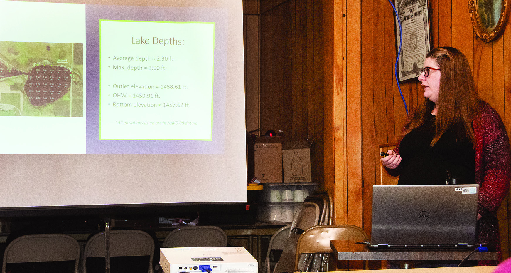
RIGHT: MAGGIE GROSS, SHALLOW LAKE SPECIALIST FOR THE DNR, gave a background of Robbins’ Marsh during a lake designation hearing last Wednesday at the Currie American Legion. LEFT: Voicing their approval of the plan Wednesday were Carl Nyquist (left) and Kevin Vickerman, two area residents with close ties to the marsh. Photos / Per Peterson
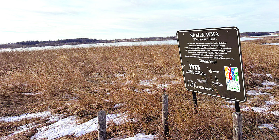
ROBBINS’ MARSH, located between Tracy and Currie, lies in the Shetek Wildlife Managment Area.
Robbins’ Marsh, locally referred to as Robbins’ Slough, is a state-owned, public 300acre body of water in Murray County, which is divided by County Road 3. It is typically about 2.3 feet deep and has had a maximum depth of 3 feet; the greatest depth recorded was about 3.8 feet in 2022.
The marsh has a long history of waterfowl hunting and aquatic furbearer trapping. Hundreds of ducks were found using the basin in 1954, the last time the area was surveyed.
As of 2022, water clarity was about 2.5 feet; the total phosphorous at the time was .09 milligrams per liter, and chlorophyll-a was .04.
“Both of those are below the MPCA threshold, so that’s really good,” said Gross. “We found five different plant species out there, and every survey point we went to had vegetation. We did notice some black bullheads that had minnows, but no carp.”
Gross said the DNR manages shallow lakes to achieve a clear-water state; clearer water allows aquatic plants to grow and provides good habitat for wildlife.
“Robbins’ Marsh is in a clear-water state,” she said. “It has on its own flipped in the past between a clear- and turbid-water state. It’s kind of cycled throughout history.”
One concern brought up last week was beaver influence at the area, particularly in the creek, which has had tendency to be very dry for periods the last few years. That, combined with any drawdown, has some locals concerned about water levels there.
“It shouldn’t affect the creek; with the outlet structure, there’s a pipeline that would go into the creek; we wouldn’t want to hold that creek higher than it should be,” said Gross. “The reason why it’s been dry is because of the beaver activity we’ve had, it’s been a continual battle. We’ve had beaver trappers out there who have removed some beaver in the area.”
The marsh has a tradition of being a haven for various critters. Historic accounts show that between 500-1,000 muskrats were trapped each year in the late 1902 and early ‘40s around the marsh. Trappers have also harvested mink and beavers from the basin; both are still present, although populations are much smaller than they were decades ago.
Local farmer Kevin Vickerman asked if the DNR would provide any kind of beaver management at the marsh.
“We try to stay on top of it,” said Gross. The public hearing and testimony given last week is a mandated part of the process the DNR needs to follow under State Statue 97A.01 to designate, preserve and manage public waters for wildlife purposes. The 30-day comment period commenced the day after the public hearing.
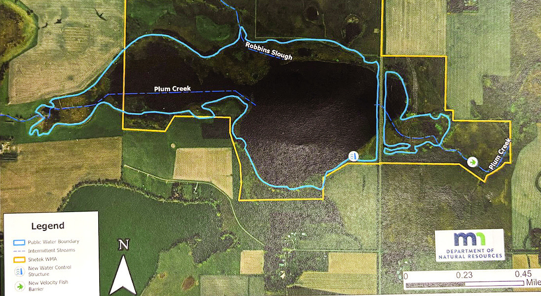
THIS IS AN AERIAL VIEW OF ROBBINS’ MARSH that illustrates the basin, wildlife management area (yellow border), inlets, outlets and locations of the proposed water fish barrier (bottom right) and control structure (bottom toward center). DNR image